Friday, November 6, 2009

Interregional High Speed Rail: which corridors work where

A recent study (PDF) from a group called America 2050 has put together one of the most data-heavy (and that's a good thing) approaches to examining high speed rail corridors in the country. There are still some issues, most notably the fact that corridors over 500 miles were ignored (yes, they should be weighted less than 200-400 mile corridors, but, no, with proper speeds attained, they shouldn't be dropped) and their map does not seem to fully mesh with their data. Still, they take in to account such factors as transit accessibility in cities analyzed, economic productivity (higher local GDP is better), traffic and air congestion and whether the city is in a megaregion (this seems to be a rather ancillary data point).

Their subsequent phasing map, while better than most, seems to be, well, not completely in-line with their data. This is mainly because each corridor seems to be analyzed separately, and overlapping corridors, from their report, are not shown well.

First, they did get the two big corridors right (the "no-brainers," if you will): California and the Northeast Corridor. Both of these corridors have multiple city pairs in the top-10 of their analysis; in California the San Francisco-San Jose-Los Angeles-San Diego line and in the northeast the Boston-New York-Philadelphia-Baltimore-Washington corridor. Of course, those are obviously the top high speed rail corridors in the country. However, the rest of their "first phase" corridors are less obvious.

In an effort to, perhaps, not leave out the Midwest (where much of the current political support for high speed rail originates), they include, in phase 1, lines from a Chicago hub to Minneapolis, Saint Louis and Detroit. These are all worthy corridors but, according to their analysis, are not in the same echelon as the coastal corridors. Chicago to Saint Louis clocks in at 14th, trailing Chicago to Columbus by a spot. Chicago to Minneapolis ranks 25th, behind corridors such as Cleveland to Washington and Phoenix to San Diego.

With Chicago to Detroit (11th), however, things get interesting. Let's introduce two maps in to the equation. The first is a map of the top 50 corridors analyzed by America 2050, with the color of a line indicating if they were in the top 50 (red), 40 (orange), 30 (green), 20 (light blue) or 10 (dark blue). Opacity is set rather low, so overlapping lines should show up considerably darker (see the Northeast Corridor, where four top-ten corridors intersect from New York to Philly). From Chicago to Minneapolis and Saint Louis, there are single lines. Despite the presence of some smaller cities (Decatur, Springfield, Urbana-Champaign; Milwaukee, Madison, Rochester) none of these corridors crack the top 50. (Milwaukee-Chicago was not calculated as it is less than 100 miles.) East of Chicago, however, there is a web of lines. From Chicago going east, three cities make the top 16: Detroit, Cleveland and Columbus. And east of there, these cities are all linked eastwards. (Any city with at least two corridors is shown with a point, its size corresponding to the number of corridors.)


So it begs the question: which routes are most applicable to high speed rail if we overlap corridors which could share significant trackage. For instance, Chicago to Detroit, Cleveland and Columbus could all share one high speed link, with short spurs to each of the cities. These three cities could all share a link across Pennsylvania (with Pittsburgh) to Washington, Philadelphia and New York. 11 of the top 50 city pairs are between New York, Philadelphia and Washington in the east and Columbus, Cleveland and Detroit in the west. Since most of the capital costs of constructing a high speed rail line is the initial capital cost, combining several corridors could dramatically reduce the amount of line needed, saving billions.

So, the second map. For this map, lines with little or no overlap were ignored. Other corridors were assigned a (rather arbitrary) point value based on their ranking:

1-10: 6 points
11-20: 4 points
21-30: 3 points
31-40: 2 points
41-50: 1 point

(Why did the top 10 get a slightly higher weight than the rest? Well, the numerical rankings of the top 10 ranged from 100 to 91. The rankings of the next 40 ranged from 91 to 85.)


Here's another scheme: assign a route with a score of 85 one point, and an additional point for each increase in the score. This is, perhaps, a more equitable approach for larger corridors, and it really pops out the Northeast Corridor. A possible network of 2450 miles (1870 in the East and Midwest, 580 in California) could serve Boston, New York, Philly, DC, Pittsburgh, Columbus, Cleveland, Detroit, Chicago, San Diego, LA, San Jose and San Francisco (and several smaller cities, like Toledo, Harrisburg and Hartford). Adding up only the top 50 MSAs served (those with populations over 1m) and 2500 miles would serve 90m people. That's not bad.


So, what's the takeaway here? Well, there are two. The first is that, as much as we want to build a multi-regional high-speed rail network, the Northeast Corridor is still, by far, the largest market for HSR in the country. The second, however, is that even when you exclude the Chicago-to-East Coast routes, the New York-to-Chicago Corridor should still be the third-highest priority to build. And if properly built (with top speeds of 200 mph or a tad more, especially across the flat land west of Canton) such a corridor could begin to compete with airlines, even on >500 mile routes.

Thursday, November 5, 2009

Soft factors that benefit car sharing

Since I work for a car sharing organization, people often ask me what makes a city or neighborhood ideal for car sharing. While certain factors are easily measurable or obvious (density, walkability, and mixed use development), others are a just as important but not as apparent. I've come up with three such "soft factors" (soft because they are not hard measurements which can be gleaned, say, from census data). These seem to be quite indicative of whether car sharing will thrive, and seem to be good for creating livable cities as well—as long as livability is not intertwined with car ownership.

They are the availability and cost of parking; the frequency, reliability and speed of a transit network; and the prevalence of urban congestion.

1. The cost and availability of parking. Owning a car is expensive. However, once you start paying for parking, you're throwing money at little more than a 100-square-foot plot of ground for your car not to drive. Once this cost gets over about $100 a month, it contributes significantly to lower car ownership. Enmeshed with this factor is the availability of parking. It's almost always possible to find street parking if you look hard enough. But if you have to circle a block six times, jockey your car in to a tiny spot, and/or move it every third day to the alternate side of the street, it makes car ownership more of a burden than a freedom.

Cities where car sharing thrives are not cities where it is easy to find a parking space. One of the major reasons car sharing took off in cities like Boston, Philadelphia and San Francisco is that they were able to advertise that their cars always had "reserved parking," a godsend for residents who had to deal with expensive private lots or arduous on-street spaces. All of the sudden, they could take a two hour car trip, get home, and not have to worry about how many blocks away the nearest spot would be. Or, if they gave up their private spot, they might find a couple grand in their pocket at the end of the year.

2. The frequency, reliability and speed of a public transit network. The three adjectives here generally go hand-in-hand-in-hand, with the exception of a minor explanation regarding speed. Speed is relative. Sure, antiquated subways in Boston, New York and Chicago may creep along through ancient tunnels or els, but compared with the gridlock above (or below)? Well, private right-of-ways do have their advantages. And are they reliable? Well, about as reliable as highways which, at any time, may devolve in to a traffic jam.

The most important piece of the transit puzzle seems to be frequency. Or to put it differently, "can you walk to the nearest bus line and get on a bus without knowing a schedule." This generally means that most lines should have midday headways of 15 minutes or less. And while grade-separated, rail transit carries a large fraction of riders in many of these cities, reliability and frequency seem to be more important to car sharing than the exact mode. Seattle, for example, was until a few months ago a bus-only transit system (We'll ignore the monorail and one-mile streetcar.) and the new light rail line doesn't serve many high-car sharing neighborhoods. Still, most lines run every ten or fifteen minutes all day and in to the evening, and while they're not particularly fast, they come pretty often.

Do a lot of car sharing users walk or bike? Yes. But if it's raining, or cold, or they just want to make use of transit, the ability to walk to the corner and not have to wait 25 minutes reduces the need and desire to own a car. (Especially when it might take that long to find a parking space; see factor 1 above.)

3. The prevalence of urban congestion. This is probably the most confusing of the three factors, since I don't mean congestion on freeways leading in to the city in the morning and out in the evening. What it refers to is the prevalence of random traffic jams and tie-ups. In other words, how often during non-peak periods (middays, evenings and weekends) is there horrible traffic for no apparent reason? How often do you get in your car and, because a lane has been blocked off or a light has malfunction or an inch of snow has fallen, a trip that should take ten minutes takes half an hour? How often do you sit and watch a light a quarter mile ahead and realize that there are 40 cars ahead of you and only two are making it through each cycle? And how often is there some event—a parade or a race or a visiting dignitary—which so screws up the traffic system that no one in their right mind would drive downtown?

In cities which support car sharing, everyone's had the experience of sitting in traffic on a Saturday afternoon for, well, no apparent reason. Urban congestion is not just that there are too many cars on the road, but that they are dynamic urban environments which sometimes don't mesh with the automobile. If one small protest or minor accident closes off a main street corner, it can cascade across the street network, creating gridlock at a time it's not expected. Of course, as anyone driving in any of these cities knows, there's no time when there's never been traffic.


Are these the only three factors which contribute to a dynamic car sharing market (or, in other words, make owning a car so unpalatable that many people do without)? Of course not. Also important are population and employment density, walkability (which has to do with these factors) and, to a small extent, the availability of bicycle facilities, the cost of gas, planning ordinances, physical geography and the like. But, from what I've seen, these are some of the most important factors, and they not only create a city with good car sharing prospects, but one in which people actually want to live.

Friday, October 30, 2009

Progressive cities: are they racist?

Andrew Sullivan has recently been blogging about an article that certain progressive cities are progressive because they have fewer African Americans. This is not only preposterous, but it completely ignores the historical perspective of minorities in cities. Take my current hometown of Minneapolis-Saint Paul, particularly Minneapolis. As late as 1970, Minneapolis was 93% white. This is rather astounding. The African American community was concentrated in a couple neighborhoods, and the rest of the city was almost completely white. (Saint Paul, while slightly more diverse, was also rather white.)

Most of the African Americans who moved north in the first half of the 20th century did so during the Great Migration, and where they moved was mainly based on the railroads. Since Chicago was the end of the Illinois Central (and other lines) which reached in to the south, most blacks stayed there (or took interurbans to Milwaukee for a few nickels). Minneapolis's industrial employment during through the war was diverse, if you count Swedes, Norwegians, Finns, Germans and Irish as diversity.

While the other cities mentioned—Austin, Seattle, Portland, Denver—have had different migration patterns, none were on rail lines which led directly back in to the black belt, so they didn't pull from the pool of African American labor in the industrialization of the early 1900s. And, thus, they are generally less diverse—if you look at diversity as purely black-and-white—than some other cities.

However, Minneapolis has changed, dramatically, over the last 40 years. The minority population, at seven percent in 1970, has increased more than fourfold, and now stands at nearly one third. Much of this has been Asian and Hispanic immigration, but a significant portion has been African Americans moving from other cities, especially Chicago. And the adjustment to a more diverse city has not been smooth. In the 1980s and 1990s, Minneapolis saw increased crime, often blamed on imported street gangs and drugs. In the 1990s, the city was nick-named Murderopolis, and saw nearly 100 murders in a year—for a city with fewer than 400,000 residents. And the change has been dramatic; in many http://www.ci.minneapolis.mn.us/neighborhoods/>neighborhoods, (an example from the Minneapolis Neighborhood website) there has been an almost full-scale switch from white to black in 20 years (all taking place after the 1980s—i.e. not done illegally through redlining), a phenomenon David Carr described last year in the Times. (Recent surveys show the racial makeup of the city may be stabilizing.)

In other words, Minneapolis is not a white city without any racial tensions. It's far from it, yet it's continued to be a rather progressive place. (Although some of this can probably be attributed to conservatives fleeing to the suburbs—the same suburbs that spawn creatures like Michele Bachmann. Minneapolis's outer suburbs are very, very red.) But in the last few years, a curious trend has emerged. Crime has been dropping, which is often attributed to more police on the streets and community development. This summer, the city had six murders in the first six months of the year, shocking some local historians. The trend has continued to be low; there have currently been about a dozen murders this year in the city, so it's on place to be at one-sixth the rate of the mid-90s.

In the mean time, the city (along with Saint Paul, which is also rather safe) has welcomed tens of thousands of new immigrants, including many Hmong and Somali refugees. There's no second language in the city—signs and materials are often translated in to Spanish, Hmong and Somali. Renn's contention that these progressive cities are only progressive because of their racial makeup holds no water. In other words, causation does not necessarily imply correlation.

Tuesday, August 25, 2009

Interregional High Speed Rail: the myth of the 400 mile cap

Recently, we began to consider interregional high speed rail, or, in other words, high speed rail spanning more than the current corridors proposed. Before we delve in to details, it's time to dispel some myths. The first one is that high speed rail is not competitive over distances of 400 miles.

No, I'm not making that up. Obviously, as distances become longer, air travel becomes more competitive, since when they are flying at cruise level, planes are faster than trains. However, making up a number, in this case 400 miles, is just not true. The problem is that very important economists writing for very important newspapers (in this case, Ed Glaeser for the Times and Robert Samuelson for the WaPo) make stuff up, and because they have degrees from places like Harvard, people believe them.

Both writers pieces have been thoroughly discredited (and there are many more such posts, like this one), but no one has mentioned one of Samuelson's rather-blatant misrepresentations. In his piece, he states as fact (without any source, of course), that
Beyond 400 to 500 miles, fast trains can't compete with planes.
. This is rather interesting. Why? because not only does he fail to mention places where trains compete comfortably with planes in a 400-500 mile corridor, but he doesn't mention either a 500+ mile corridor where a train line doesn't compete or offer any rationale about why they couldn't.

So, I'll do his dirty work for him. First of all, let's find a city pair with high speed rail of greater than 400 miles. Say, Paris to Marseille. By air, it's 406 miles, by road, it's about 482. Either way, it's in Samuelson's not-really-competitive range. Here's the interesting thing. Of the air-rail market on the Paris-Marseille route, the TGV has taken 69% of the traffic. That's up from 22% before completion of the line. I think that's competitive.

In fact, it's time, not distance, that governs competitiveness, and the time is definitely more than three hours. According to SNCF's Guillaume Pepy
High-speed rail has historically captured the major share of combined air/rail traffic along routes where train journeys are under 3 hours. But this is changing, says SNCF's Pepy: "With air travel becoming more complicated and increasing airport congestion, high-speed rail now wins 50% of the traffic where rail journeys are 4.5 hours or less," he said. On the Paris-Perpignan route (5 hrs by train), TGV has 51% of the air/rail market, on Paris-Toulon (4 hrs) 68%.


It seems that, even for trips of four or five hours, high speed rail can be competitive. In that amount of time, a train averaging 160 mph could cover 640 to 800 miles. If that is the case, then a lot more corridors are plausible for consideration for high speed rail including a route between the East Coast and the Midwest. Especially between cities with congested airports. In other words, New York and Chicago.

Wednesday, August 12, 2009

The strange tale of the 21, 53 and 63

This was originally posted as a comment on the Minneapolis Transit blog about increasing limited bus service.

1. Cutting service on the Selby section of the line to every 26-28 minutes is probably not a good idea. The line is rather well-patronized along that section with the current 20 minute headways and reducing it beyond that would make it much less useful (I think it should have more frequent headways, every 15 minutes, anyway). There's a lot of land along Selby which is either vacant or parking, and better transit service might serve as a catalyst for redevelopment. A better economy would help, too, of course.

2. The 21D is a farce. Supposedly it was wrangled by Saint Thomas in order to have better transit, but it is usually empty until it clears the river. The worst part is, however, that the 20 minute headways on the 21D match the 20 minute headways on the 63 which ends at the same stop, but no one at MetroTransit has ever thought of interlining (I asked). How much sense would that make? Lots. Grand Avenue's line would no longer dead-end at Saint Thomas, providing access from Grand to the LRT (to Minneapolis and the airport) and Uptown.

Furthermore, of the buses that run west from Saint Paul more than twice an hour (the 3, 16, 21, 63, 74 and 54), the 63 is the only one without a western "anchor." The 3 and 16 run to the U and downtown Minneapolis, the 21 to Uptown and the 54 and 74 to the Light Rail. The 63 ends in a residential neighborhood in Saint Paul. Finally, going from Grand Avenue to Downtown Minneapolis requires two transfers (unless you go east to Saint Paul, not feasible from the western part of the route), which is time consuming and inconvenient. Interlining with the 21D would solve many problems with little or no additional service required (except, perhaps, when the 21D doesn't run at rush hour). Running the 63 in to Minneapolis seems almost intuitive. I guess that's why it hasn't been done.

3. The bus stops along the 21 line from Uptown to Hiawatha (and in most of the Twin Cities) are way too close together. Since there is often someone getting on at every block, the bus winds up pulling in and out of every stop. No wonder it is scheduled to complete this section of route in 25 minutes, at a speed of less than 10 mph. If bus stops were halved few people would notice the longer walk (still generally under 1/10 miles) and the buses would be speedier. Plus, what it its real utility when it doesn't run at rush hours?!

4. Finally, the jog to University is very helpful for people who want to transfer there, but very time-consuming for through-riders on the 21. Perhaps the midday 53 could, instead of using the Interstate from Snelling to downtown, use Selby, with stops every 1/2 mile at major cross streets (Hamline, Lexington, Victoria, Dale, Western).

When this was changed some time around 2004 (from the historic Selby-Lake route dating back to the streetcar era), it increased the utility for travel to University and a transfer to the 16, but decreased the utility for cross-town trips by adding to the already-long run time of the bus. Considering how many people transfer to and from the 21 at University, it seems like it would almost make sense to have one leg of the 21 run on Selby to University and Snelling, and then west on University to Minneapolis, and another to run on University from Saint Paul to Snelling, and then west on Marshall and Lake to Uptown. Better 53 service would, of course, help as well, and just cutting off that jog, with half a dozen lights and a mile of extra route, would cut service times.

Monday, August 10, 2009

Interregional High Speed Rail: mapping its genesis

This topic was raised by an IM discussion I was having with my dad as he sat on the tarmac on a plane in Saint Louis:
Dad: My flight has now been delayed a total of 2:35 on account of, they say, air traffic control in Boston because of weather.
Me: Hey question: if you could take a 6 hour train ride from Saint Louis to Boston (feasible, albeit barely) would you rather do that than deal with these airplane shenanigans?
Dad: You betcha. There ought to be a 90-minute hop from here to Chi, and then the eastbound super-express. What route would you propose for that?
Ask and you shall receive.

Before going in to the route (in a separate post to come later), it would be interesting to see what has been proposed for high speed rail routes, and what the genesis of such proposals has been. There have been several, and it is actually quite interesting how they have evolved. What I am going to try to illustrate here is that high speed rail has too-often been touted as a regional solution; it is really an interregional solution as well. Thus, I am consistently flummoxed that few maps show an interest in an East Coast-to-Chicago trunk line, paralleling one of the most congested and delay-prone air routes in the world. (Mention O'Hare and JFK, Newark or LaGuardia in the same breath and seasoned travelers will curse or faint.)

So, now to the maps. I've tried to link them in as best I can, but my apologies if some of the links break: some of these maps are rather old. We'll start way back in the year 2000, when the Bureau of Transportation Statistics published an early draft of an HSR network. It should be noted that this was eons ago in the life cycle of high speed rail. Gas was cheap, airlines were profitable (ha!), and the Acela hadn't yet run from Boston to Washington.


In general, this looks pretty similar to some of the more recent maps. So it's pretty much a base. Which is problematic: once people have drawn lines on maps, it's often hard to redraw them, no matter how little sense they make. Luckily, as a base, most of the nonsense here comes from connections not made, like not linking networks in Jacksonville and Tampa, Houston and Austin or DFW, and Cleveland and Pittsburgh. It's the last of these which, as we'll see, is somewhat persistent.

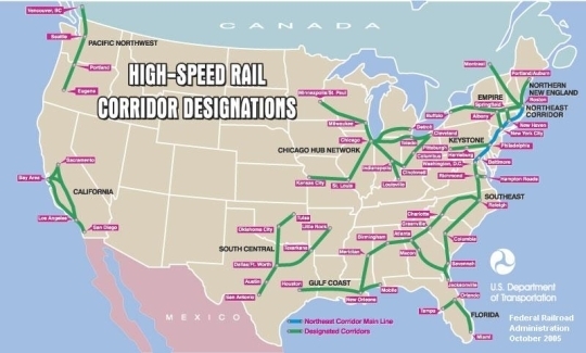
High speed rail didn't come up much during the Bush Administration (which was preoccupied with throwing enough money to build these entire systems show here at the Iraq money pit), but a new map (from the DOT) was offered up in 2005, which was a general template for the next several years. And it was ... pretty similar to the previous one.


It was being used by several sources as late as this year. In other words, from 2000 to 2009 there were basically no changes made.

Finally, the Obama administration, which has now promised money to high speed rail, released their own map, and, well, didn't rock too many boats. Their "Vision for High Speed Rail in America" is not much more than a couple of tweaks of the existing map. And still, ten years later, regions are, for some reason, not linked.


In the mean time, there have been several regional agencies which have come up with their own maps. The two most prominent are in the Midwest and California. California's map is relatively simple (although minor changes, such as which pass to use to get from the Bay Area to the Central Valley, have been the cause of much contention) and very nifty on their website. The Midwest map, which is less further along, has seen a bit more flux.

The first map released by the Midwest High Speed Rail authority was rather modest, vague and, frankly, not really high speed rail (with top speeds of 110 mph):


That map disappeared from their server earlier this year (the Web Archive grabbed it, however) and a new, more ambitious one arrived, along with the news that they'd push for 220 mph service from Chicago to Saint Louis (ooh, good idea):


This is actually one of the better maps I've seen. It might be overly ambitious, but it does show the high speed routes to major cities, with connections to the east coast, which have been missing previously. Of course, there is no straight line across the Midwest from Pittsburgh, but at least the network realizes that it should be interregional.

Finally, there are a bunch of maps created by various blogs and lobbying groups for high speed rail networks.

The Transport Politic blog offers:


Richard Florida talks about Megaregions and high speed rail without putting up a specific map (a good idea, perhaps)


But others take that map and run with it.


Finally, with that map as a base, a lobbying group called the United States High Speed Rail Association has an ambitious, 17,000 mile network.


So what's the takeaway? Well, the first is that nothing is really set in stone (except, perhaps, in California). But the second is that only more recently has anyone started looking beyond the corridors first set forth in 2000 (and, presumably, even before then). Which is good. Because even the newest maps, none of which have the backing of the government, have some issues with linking together longer corridors. Both the USHSR's map and the one from the Transport Politic go through Philly, Harrisburg, Pittsburgh, Cleveland and Toledo on their way from New York to Chicago, adding enough mileage to negate the use of the corridor for longer distances.

Update: America 2050 has posted a study that actually has some basis to it, and the map they create is probably the most sensible yet.. The Transport Politic thinks so, too.

In any case, these maps should be refined: a strong case could be made for the competitiveness of a high-speed line from New York (with branches to Philadelphia, D.C. and even Boston) to Chicago (with branches to Pittsburgh, Cleveland, Detroit, Columbus and other cities). Considering the dismal state of air service between the first and third largest cities in the country, and the horrors of getting from the CBD of each (the two largest downtowns in the nation) to the airports, a modern, 200 mph line could definitely hold its own.

A future post will discuss this.

Tuesday, August 4, 2009

Cash for clunkers: proof that a gas tax would work?

There has been a lot of debate as to the overall efficacy of the Car Allowance Rebate System, (legislators love acronyms) colloquially known as "Cash for Clunkers." On a few subjects there isn't much contention: it has been "successful" in getting people to buy new, and generally more efficient, cars. In other words, if people have a financial incentive to trade up to a more efficient car, they will do so. Especially if the incentive is (probably) set too high.

So, I'm not down on Cash for Clunkers. First of all, it's proof that a government program can work. It was quick and effective and probably stimulative (more so than environmental)--most of the cars in the program were made in the United States. That's good in that it may help convince some anti-government types that government is not always the problem. Second, it is not increasing the number of cars on the road. While it is certainly not perfect, a far more worrisome development would have been a program that mailed out checks to people to buy new cars; a program which I could see government embracing. Third, it can't be debated that the new cars on the road are, in fact, less polluting than the current ones. While not everyone went out and bought the newest Prius (although many are), a 60% gain in efficiency is nothing to scoff at. Even if these cars may be driven more than their predecessors (since they'll be new and reliable and, well, not clunkers) there will likely be an overall decrease in emissions.

On the other hand, the program could have, obviously, been better administered. First of all, $3500 to $4500 is a lot of money. I thought about buying a clunker, trading it in, buying a new car and turning around and selling that--even with the title transfers, time involved and money lost to depreciation, I'd probably clear a couple grand. (I'm not sure, however, if I could have qualified with a new-to-me clunker.) In any case, smaller sums--$1000 to $2000--would have likely resulted in many sales but not the veritable run on the bank that car dealers have recently seen. In addition, there was no provision for people with clunkers who wanted to get out of car ownership completely. The only way they could do so would be to trade in the clunker, buy a new car, and turn around and sell it. Maybe the next program should be that if you bring in an old car, the government will give you a year-long transit pass for the agency of your choice and a $1000 credit for your local car sharing agency. This, too, would cost less than $3500, and dramatically reduce emissions and the number of cars in the road. (Yes, I have a bit of a vested interest in the second half of this proposal.)

While the transit-car sharing idea is a bit of a pipe dream, politically, one which is less of one would be a better-graduated system. The CARS program had hard cutoffs. If you car gets tenth of a mile per gallon over the limit, you get nothing. A tenth less and nearly $5000 can be in your pocket. Furthermore, you get this money whether you upgrade to a still-overpowered sedan or SUV getting in the low 20s or a Prius (or similar) getting twice that. So what would make more sense would be a graduated system. Trade in an 18 mpg car and go to a 22 mpg and we'll give you a few hundred dollars for your trouble. Go from a 14 mpg SUV to a Prius (or a similarly "clean" car), and you can cash in on the full $4500. Or more.

That's all well and good and probably won't happen. Nor will credits for transit commuters, cyclists and others who choose not to drive. It costs too much money and isn't terribly stimulative and probably doesn't have the votes. Furthermore, the CARS program was very simple. Your vehicle either does or does not qualify, and you can get either $3500 or $4500. For these others, we'd need charts. And if you put mathematics in between an American consumer and a deal, they're far less likely to do it. In other words, if you make it as confusing as doing your taxes, people are going to like it about as much.

There is a relatively simple way to achieve nearly all of these objectives. It would require little administration, since the methods of collection and distribution are already in place (and have been for years, and work fine). Yet, for a variety of reasons, it is a political third rail. It is, of course, the gas tax.

The federal gas tax is 18.4 cents per gallon. That's right. 18.4 cents. Most states have their own taxes on top (Alaska is the only holdout) raising the total tax as high as 60¢, in New York State. The federal portion was last raised in 1991. Yup, 18 years ago. Since then, prices have increased 58%. Had the gas tax kept up, it would be 29¢ today. The gas tax in 1991, however, accounted for about 17% of the cost of a gallon of gas (at that time, gas, with the tax, cost about $1.20). If gas taxes were based on percentages, they would be about 43¢, and last summer would have crept to nearly 70¢.

So, it's obvious that gas taxes are low. And it's also pretty obvious that there is some climate stuff going on, and that having people use less gas would be beneficial. In addition, using less gas would keep prices lower and supplies more stable, as well as encouraging energy independence. These are all good externalities, but, perhaps most importantly, the gas tax, if it is adjusted for some rural populations and low income communities, is a very efficient way to raise tax revenues.

Mention raising the gas tax and you'll hear two responses. One is "it's not politically possible." The other is "it's regressive." The first is, sadly, perhaps true. The second is not, and, particularly when it is offset with some sort of tax credit, potentially a straw man. When the tax was last raised, 18 years ago, this was debunked. In several manners, it has to do with how you look at gasoline: whether it is a necessity or a luxury. If it is a necessity, then, yes, the tax is likely somewhat regressive. This is the reason we don't place punitive taxes on clothing and food: you need both to survive. Gasoline, however, is a different story. In New York City, 55% of the residents do without a car. Yes, it's a special case. But is there anywhere where more than half the residents do without food or clothing? In several other major cities, more than a quarter of households don't have cars. For some it is an economic decision. For others, it is about lifestyle. But it is rather obvious that, especially in areas with decent public transport, owning a car is not a necessity.

And for these people, which number in the millions, a gas tax is not regressive at all. Many of them are the same people who the highway lobby defends; the people for whom a gas tax will be painfully regressive. However, as long as they aren't driving a gas tax will have no effect, although it might drive more people towards transit use and increase service levels.

The other worrisome issue are those people who live in rural areas. For them, higher gas taxes will result in higher costs, because living at a low density tends to require a lot of driving. And for farmers, a rise in gas prices will create a rise in production costs, for both mechanized agriculture and transportation. There are two ways of dealing with this issue. One is direct subsidies to growers to buy cheaper fuel, although such a system would be fraught with fraud and inefficiencies. (If we'll sell you 10 gallons of cheap gas, is there much of an incentive to economize and only use nine?) A simpler way, of course, is to pass the costs along: food prices might rise a bit, but everyone would have increased costs, and everyone would pay. In addition, there would be a fine incentive to save fuel, which would both reduce costs and be more environmental. For those who live rurally for the lifestyle, they've made a choice to live a car-dependent (and fuel-dependent) lifestyle. It's only fair that they pay more.

Finally, there is a way to make sure that a gas tax would both not hit the poor especially hard and be stimulative as well: return the extra money spent on gas, in advance, as a tax credit. Estimate the amount of gas used per year (recently about 140 billion gallons) and the amount of money that, say, a $1 gas tax increase would raise (with less use, about $120 billion). Knowing that that revenue increase was in store, the government could turn around and write a $500 check to every tax payer in the country at the beginning of the year. A nice letter could be enclosed:
We know that we're increasing your gas tax. Here's $500. If you need it for gas, use it for gas. If you want to buy a more efficient car, here's some help to buy a new car. If you are interested in local transit service, here's a website where you can find out more. Here's information about car sharing, car pooling and other fuel saving techniques, too.

Oh, and enjoy the $500!

People worried about fuel costs could save the money for the year. Many others would spend the money in ways that would stimulate the economy. Others would, in the face of higher gas prices, use it for transit passes. And it would be a very progressive tax rebate: it would benefit those at lower income levels far more than those at the top.

In the long run we might, as a society, want to use this money to fund more effective transportation policies. Maybe the amount would decrease by $50 a year as people got more used to higher taxes, by driving more efficient vehicles or driving less. Any extra money could be put towards funding expansion and operation of transit agencies, and building new energy and transportation networks (as the current gas tax is earmarked for transportation). In the short run, as has been discussed in several places (including liberal blogs), consensus is that we can't get everyone out of their cars tomorrow. But instead of expanding the Cash for Clunkers program, and making it more top-heavy and unwieldy, a gas tax would likely give us better results with easier implementation (since it's already implemented).

And if everyone were promised a $500 check from the government, it just might be possible.