There's a lot of chatter about a proposed development on an otherwise-unused piece of land in Allston. It's been mentioned in the Boston Globe, on The Atlantic Cities and elsewhere. It's not the size of the development, but what it lacks: the property owner plans to build 44 apartments without a single private parking space.
Boston, like most other cities, has minimum parking requirements for new development. This is the case even though much of the older housing stock has no parking, and it still perfectly habitable and in many cases quite desirable. But since the 1950s, adding housing without adding lots of parking has been frowned upon. In order to have even a chance to get the plan through the zoning board, the developer, Sebastian Mariscal, is throwing out all sorts of mitigation efforts. These include public green space, private gardens for each unit, storage units, bike parking (two spots per unit) and storage lockers. But he goes further still: he proposes making each resident sign a lease addendum that, while living in the development, they will not own a car.
It is this rather radical part of the plan that has gotten a lot of attention, and in some cases, praise. I don't fault Mariscal for proposing it, but he shouldn't have to. The minimum number of parking spaces a developer builds should be dictated by the market, not by the zoning board of appeals. If a developer wants to build a lower number of parking spaces than would be allowable, they should darn well be able to. Forcing them to build more spaces increases the cost of each unit, which in turn reduces the amount of housing available, which in turn raises the cost for everyone.
Neighbors may whine about the potential for reduced parking availability clogged streets and gridlock, but their complaints should fall on tin ears. There is no guaranteed right to parking. Especially in a neighborhood like Allston, which, as the Atlantic points out, is mostly pavement, there should be ample parking available to those who need it. If the area is developed enough that there is a dearth of parking (and 44 units won't do this), someone who owns a driveway or parking lot will rent spaces. Then residents can use the marketplace to decide between the cost of a guaranteed, monthly parking spot and the time it takes to search for street parking.
Cities should have a vested interest in making sure that parking is not overbuilt. Too much parking raises the cost of housing, detracts from street life and, as cost for parking falls, disincentivizes the use of alternative modes of transportation. But disallowing projects because they fail to provide parking only serves to drive up the cost of housing, increase congestion and pollution and, in turn, detract from the city's tax base as less housing is built. In addition, if more parking is built than required, it can lead to half-empty concrete parking hulks which have too much sunk cost to be converted to another use (see: Kendall Square). Plus, Allston has plenty of parking, even though you don't need a car. The proposed housing is a stone's throw from a drug store, a major supermarket, half a dozen bus lines and the streetcar. It's a place that doesn't need parking. So why force it to be built?
Toronto has allowed a skyscraper—first proposed in 2011—to go forward with 42 stories, 315 units and no parking spaces. The developer said "if we couldn’t sell a unit without providing a parking spot, then we wouldn’t be selling those units. The proof is in the pudding—we sold 270 units without parking in nine days." And, so far, Toronto has not (yet) devolved in to a gridlock of traffic looking for a parking space.
Lack of parking is a perfect instance in which the free market should take charge. It's high time that cities stop meddling in developers way and let them build the housing they want to build, whether it has "enough" parking or not.
Wednesday, February 27, 2013
Friday, February 22, 2013
Literal NIMBY
Down the street from where I live in Cambridgeport, there is a church which has closed and is slated to be redeveloped. (This is not without precedent, there is a church a couple of blocks away which was also turned in to apartments.) In a neighborhood with some of the highest rents in the city and a very tight market, more supply will serve to both stabilize prices and to add tax base from a previously un-taxed parcel.
Of course, there are people who are against development. People in Central Square push parking lots over density, and claim more housing will turn the area in to an uninhabitable hellscape. That's silly, but that's up the street. There's an organization which wants to "save" 56 Magazine by—well, by keeping it a mostly unused, run-down church building. They claim that Cambridge needs more communal space. This might be true, but they want to subvert the free market to keep a religious institution, well, something. Even as the demographics of the city have changed and there are many fewer church-goers to fill these spaces. And even though there's a perfectly good park not a block away. Oh, yeah, it's in a perfectly walkable neighborhood, one of twelve examples profiled by Julie Campoli in her book Made for Walking.
So who are these 56 Magazine people? Well, I'm not completely sure, but their address is interesting. It's 60 Magazine. And for the record, there is no 58 Magazine. So, quite literally, these are NIMBYs. Or, maybe NIMSYs—not in my side yard. I took a picture:

So the people who live in the house to the right don't want construction and activity in the building to the left. So they are trying to create a non-profit advocacy group about it. At least they're transparent about it—or at least their address.
Thursday, February 21, 2013
On US Olympic Bids
The Boston Globe has a column today about US Olympic bids, touting smaller cities chances at bidding for the summer games, including Boston. While Boston could probably hold a summer Olympics (hey, Atlanta did to, well, not quite universal acclaim), it might be a bit of overkill. The city doesn't need the new baseball stadium (well, it does, but Fenway will live forever) that Atlanta did to justify building an Olympic stadium, the transit system would be strained between venues. While some sports, like rowing and sailing would have terrific natural venues, others, namely high profile events like swimming and track and field, would require major stadium investments the city does not need to make. (The timing would have been right around 2000 to build a stadium the Patriots could have then used, but they have a perfectly good field in Foxboro.)
Plus, the 2024 Olympics are probably not going to go to the US anyway. The bids for 2020 are down to Istanbul, Tokyo and Madrid. Rumor has it that the IOC may look more towards Africa and Asia beyond then, particularly if Tokyo or Madrid wins in 2020. And while it is true that the US will not have hosted a summer games in 28 years, they hosted in 1984 as well (so that makes two in 40 years) and a city would probably have to come in with a strong bid to have a chance. (Chicago and New York flailed for 2012 and 2016.)
 The winter games, on the other hand, might make more sense to bid. First of all, there are many fewer cities which can host a winter games. South America, Australia and Africa are out. In recent years, the IOC has moved away from awarding the games to tiny alpine towns as the games—and lucrative spectators—have grown. While the next two Olympics are in smaller cities, they are nowhere near the towns of a few thousand which hosted the games in 1992 and 1994. (Pyeongchang is quite small, but the indoor events in 2018 are taking place in the larger city of Gangneung.) In addition, the trend in recent years has been to have valley-mountain Olympics, where indoor-based venues are held in one location (generally in a city) and outdoor events held at a location further afield.
The Winter Olympics generally rotate between Europe, Asia and North America. The North Americans would be up for the games again in 2022, but a bid appears unlikely, and a European city (Munich was second in 2018 and would be a strong contender, as would Oslo and others) will likely see the games. In 2016 it will have been 16 years since a North American Winter Olympiad, and 24 since the games were held in the US.
So a US city would be a strong contender with a good enough bid. Unlike the summer Olympics, which can be held pretty much anywhere, there are a few course requirements which dictate where the winter games can be held (in addition to the need for snow). The first is the Downhill ski event, which requires a vertical drop of at least 800 meters (2600 feet). A not-high-or-steep-enough hill has been a thorn in the side of Quebec City's hopes for the games (even though it would otherwise make a great host); Montreal would have to look south across the border for enough elevation and multinational bids are not well-received by the IOC. The second issue is that there is an altitude limit of 1800 meters (5800 feet) as the maximum height for cross country ski courses, so while they don't need to start much lower (they only need 25 meters of climb) this becomes an issue for many western venues which only see snow up high. (In 2002, Soldier Hollow just barely squeaked in under the height limit.)
There are also other considerations. A city which would not need to build much new infrastructure (both for indoor arenas and for transportation) would certainly be ahead of a city that did. In addition, it should be assumed that housing for athletes would be built anew and then converted by the city to suit its needs (most of the cities here could use new housing stock). Finally, a city with some winter sports pedigree would be more likely to host the games than one which just happened to be near a ski slope.
Here are some potential cities, and issues which arise with each. I've highlighted each category in either Green (good), Yellow (would need some improvements), Orange (could be a major issue) or Red (would preclude the games, such as the ski slope height in Quebec). I'll assume that, for every location, a Nordic venue would require full snow making.
Boston:
- Alpine: Several locations within 2-3 hours have adequate elevation, but may require new construction, potentially in an ecologically sensitive area.
- Nordic: Several potential locations near the city.
- Indoor Arenas: Existing arenas could be used with minor modifications.
- Urban Infrastructure: Existing infrastructure could handle in-city traffic, modifications may be required to outlying events.
- Other: Strong local winter sports history, especially hockey.
New York:
- Alpine: While there is a potential location in the Catskills, it is an ecologically sensitive area and there would likely be dramatic opposition to construction there. This might preclude New York as a candidate. (Large-enough downhill venues in New York or Vermont are several hours away and would require major infrastructure investments to be nearby, although a joint Placid/NYC bid might be doable.)
- Nordic: Several potential not too far from the city. If you wanted to get creative, you could hold cross country ski events in Van Cortlandt Park in the Bronx adjacent to the 1 Train, home to what is probably the world's most famous cross country running venue, which has the requisite climb (this might requiring transporting snow from off-site). This would require using the bridges over the Henry Hudson Parkway, but at 11m wide, they'd be plenty wide enough to meet standards, and the park has enough topography for the necessary climbs. (edited 2018)
- Indoor Arenas: Existing arenas could be used with minor modifications.
- Urban Infrastructure: Existing infrastructure could handle in-city traffic, modifications may be required to outlying events.
- Other: Strong local winter sports history, especially hockey.
Albany:
- Alpine: Whiteface is about 2 hours from the city and could be used.
- Nordic: Several potential locations near the city.
- Indoor Arenas: New infrastructure would likely be required to handle events. Some events could be held in New York City arenas, but this would create a long distance between outlying areas.
- Urban Infrastructure: Existing infrastructure would need to be significantly upgraded.
- Other: A small city without much major winter sports pedigree.
Minneapolis:
- Alpine: The highest elevation in the state is 2300 feet. The lowest is 600. In the state. (This would kill bids from other Midwestern cities as well).
- Nordic: Several potential locations in the city.
- Indoor Arenas: Existing arenas could be used with minor modifications.
- Urban Infrastructure: Existing infrastructure could handle in-city traffic, modifications may be required to outlying events.
- Other: Strong local winter sports history, especially hockey and Nordic skiing.
Denver:
- Alpine: Many locations nearby.
- Nordic: Areas below 1800m receive very sporadic snow and would require new construction and massive snow making / snow hauling efforts. However, such an area, unless it was easily accessible to the urban core, would not be utilized after the games as there is natural snow skiing nearby.
- Indoor Arenas: Existing arenas could be used with minor modifications.
- Urban Infrastructure: Existing infrastructure could handle in-city traffic, modifications may be required to outlying events.
- Other: Strong local winter sports history, especially hockey and Alpine skiing. However, Denver bid for and then turned down the 1976 games, which is still a cause of bitterness with the IOC. They would need a very strong bid to overcome this. (Colorado's politics have changed dramatically, however, in the past 40 years.)
Salt Lake City:
- Alpine: Many locations nearby
- Nordic: Soldier Hollow.
- Indoor Arenas: Existing arenas could be used with minor modifications.
- Urban Infrastructure: Existing infrastructure could handle in-city traffic, some modifications may be required to outlying events.
- Other: The city hosted the games in 2002, and the USOC would probably want to run another city's bid if it were up to snuff.
Reno:
- Alpine: Many locations in the Tahoe area.
- Nordic: All developed Nordic areas are well above 5800 feet (the level of lake Tahoe is 6200). A new area would have to be built at a lower elevation where snow would be more sporadic and require snow making, and would not be used after the games because there is good natural snow nearby.
- Indoor Arenas: New infrastructure would be required.
- Urban Infrastructure: New infrastructure would be required.
- Other: While the Lake Tahoe area has a strong winter sports pedigree, Reno itself does not.
Seattle:
- Alpine: Many locations nearby
- Nordic: Several mountain locations
- Indoor Arenas: Most existing arenas could be used with minor modifications, but a new ice arena might be necessary.
- Urban Infrastructure: Existing infrastructure could handle in-city traffic, modifications may be required to outlying events.
- Other: While the mountainous areas near Seattle have a strong winter sports history, Seattle itself does not—for instance, it is the only large city on this list without a professional hockey team.
Looking at this list, Minneapolis would be out lacking mountains and New York likely would as well (unless it partnered with Lake Placid, which would vault it up the list, given, for instance, that there are three major ice arenas Brooklyn, Manhattan and Newark). Reno and Albany are both rather small, and each has a venue issue (Reno with no low-enough Nordic venue, Albany with a far-away Alpine hill). That leaves Denver, Salt Lake City, Seattle and Boston. Denver and Salt Lake both have historic issues. Salt Lake hosted recently and the US would probably want to run another city. Denver would make a fine host (with the exception of finding a suitable Nordic venue) but 2026 would be the 50th anniversary of their snub (the only time a city has turned down the games) and the IOC holds grudges almost to the degree that they take bribes.
So that leaves Seattle and Boston. Seattle would make a fine host, although it doesn't have a strong winter sports history to the extent that some other cities do (for instance, it has no major pro or college hockey team) and thus might need a major new ice venue. So that leaves Boston.
Boston, I think, would do well with the winter games. With several college venues, the city would have no problem hosting the indoor sports; there are several arenas that could host curling and speed skating (with the added bonus of curling fans in Canada being a not-too-long car trip away). Preliminary hockey rounds could be held in cities across New England (Providence, Hartford, Worcester, Burlington, Manchester, Portland) bring the Olympics to nearby cities and freeing up venue space in town for skating events. Like any new Olympic city, Boston would have to build a sliding center to accommodate the sliding events, and ski jumps for jumping. Oh, and a speed skating event. That brings us to the Nordic and Alpine venues.
There is a website promoting the 2026 games (which has a Facebook page, too—with more likes than the summer page—and an article about it) and it hits on some of the same issues I do here. It promotes Fenway as an Olympic stadium (that would be fun; it did host the Winter Classic a few years back) but it sort of glosses over the Alpine and Nordic events. It mentions locations in New Hampshire and Vermont and—that's about it. In other words, no, please don't put the Nordic events at Bretton Woods.
Here are some things I think.
For Nordic, elevation is not an issue, except that there needs to be enough height differential for a homologated course. The main issue would be the ability to make and keep snow, and any venue in or south of Boston would be iffy (and climate change could render this whole operation moot). However, to the north and west, it would probably be fine. There needs to be room for 10 kilometers of trail, two stadia (for Nordic and Biathlon) and decent access for spectators. An added bonus would be a location which allowed for continued use after the games. Here are some options:
- Mary Cummings Park in Burlington is owned by the City of Boston and underutilized. It would have space for stadiums and the requisite elevation differential. It is far enough inland that it is probably cold enough to make snow, there is a major water storage facility which could provide water and pressure. It is not on an existing rail line, but could be connected to transit by buses (in fact, the 350 bus already passes the venue hourly). Politically, it's owned by the City of Boston but barely used for anything, so it might be easy to redevelop for active recreation. Along with Prospect (below), it is probably the closest feasible venue to Boston.
- Just as close, and also somewhat underutilized and owned by the City of Waltham, Prospect Park could have a heck of a cross country course. There has been a move in recent years to steeper hills, and a course which climbed the old ski hills a couple times would really test the skiers. Transit is a bit of an issue (the 70A passes nearby, and the southern end of the park is only a mile from downtown Waltham) although a light rail or commuter rail spur could be built along the old Mass Central to serve the southern end of the park. (This could actually be built as a loop branching off of the current Fitchburg Line just west 128 and looping back through North Waltham; three miles of existing right of way would not be terribly expensive.) A temporary stadium could be built in the parking lots of some of the nearby office parks to the west of the park, which would also have spectator parking. The park already has several manmade structures (water tanks, radio towers and the like) but would need to have trails built, although it could enhance the current eroded trails, especially along the old ski hill. Snowmaking might be an issue, but it's no warmer, really, than Mary Cummings.
- Great Brook Farm State Park has a ski concession and the requisite elevation (barely). Snow making temperatures would not be an issue, but water capacity might. Transportation capacity is limited, although buses from rail lines nearby would be feasible, albeit on narrow roads. In addition, building trails in the park might be an ecological issue in the rural town.
- Wachusett Mountain would be a fine location for a Nordic venue. Elevation is available to the northwest of the mountain or east (south of Wachusett Lake) or northeast of Route 140. It would also have room for a sliding facility and jumping area. It is further from Boston, but if combined with snowboarding and some smaller-hill ski events it could justify a four-mile rail spur to serve the complex. Such a spur could be utilized in the future to serve this facility. This would probably be the best option.
- The Wapack Range has the requisite snow and elevation for Nordic venues, although it would be constrained by infrastructure with steep, narrow roads. Windblown was talked about as a Nordic venue a few years ago, and Mount Watatic in Massachusetts might be suitable a well, but Wachusett seems like a better bet.
- The Merrimack Valley in New Hampshire would have several potential venues near potential rail transit and current highways.
- Brattleboro has an existing ski jump which could be used for jumping events. It's only an hour drive from Wachusett (albeit on Route 2) and the state and feds are putting a lot of money in to upgrading the rail line from Springfield to Vermont, which is within a mile of the ski jump.
- Further north in New Hampshire, several current ski areas could host events, but obviously are further and have more access issues.
Here's how the Wachusett area could be set up to host jumping, sliding, Nordic and smaller downhill and snowboard events:
For Alpine the main issue is finding somewhere with 800 meters of elevation. I'd suggest holding snowboarding events at Wachusett, and building a sliding, Nordic and potentially jumping area nearby to justify infrastructure improvements (including a rail spur from the Fitchburg commuter line, which could support one-hour rail serve to Downtown Boston). For downhill events, there are several options, but most are further from Boston:
View Wachusett in a larger map
For Alpine the main issue is finding somewhere with 800 meters of elevation. I'd suggest holding snowboarding events at Wachusett, and building a sliding, Nordic and potentially jumping area nearby to justify infrastructure improvements (including a rail spur from the Fitchburg commuter line, which could support one-hour rail serve to Downtown Boston). For downhill events, there are several options, but most are further from Boston:
- There are a couple of resorts in New England with enough elevation to hold an Olympic-level downhill event (or which would need very minor modifications to meet the criteria). They are, however, rather far from Boston. Killington has more than enough elevation, and its main issue is that it is 25 miles from the nearest Interstate (although compared to the Sea-to-Sky highway in 2010, this is a minor issue). More importantly, Killington's downhill is not well suited for the event. In Vermont, Sugarbush would also qualify, but it is a more-than-three hour drive from Boston. In Maine, Sugarloaf would be a fine venue, but it is four hours from Boston. No mountain in New Hampshire comes close to the required vertical.
- There are a few areas which have the requisite elevation for a purpose-built downhill slope but wouldn't be usable for a variety of reasons. Several of these can be tossed out immediately, such as Tuckerman Ravine (which is USFS very-protected land, has frequent visibility issues, avalanches and will not have a lift constructed, ever), Mount Moosilauke (ecological impediments, Dartmouth owns the whole thing) and Camel's Hump (ecological). Although in Sapporo they did build a downhill course in a national park, and then let it revegetate after the games.
This leaves areas with 2600 foot downhills, good road connections and nearby downhill areas to serve other events. The first two that stick out for me are near Loon Mountain, the north side of the Winooski River in Vermont and Ascutney:
- Loon is probably the best option. It is a two-hour, all-interstate drive from Boston (and if rail service were extended to Concord, New Hampshire, it would preclude the need to dramatically limit traffic on the gridlocked southern portion of I-93; the venue itself would be accessible by rail, although it might be a good excuse to extend carpool lanes and use them for bus service during the games) and the current mountain could easily support every event except the downhill. One option would be to build a new trail from the top Scar Ridge just east of Loon to the Kancamagus highway below. This would have a major visual impact, however, and would barely make it to the requisite height requirement. It would, however, require only one new lift from the current summit of Loon. The second Loon option would be to look across the valley. It would require a new trail to be built on the southern flank of Mount Liberty, but this construction would not impinge on the current Osseo hiking trail, and would rise only to about 3800 feet. It would require a stadium below, but this could be built somewhere in the vicinity of the condo developments along the Kancamagus. The hill would have southern exposure, and require snowmaking to guarantee snow. With both there options, the main issue would be ecology and forest service bureaucracy—they both extend in to the fragile subalpine zone and any trees cut would take years to regenerate even if the trail was only used for the one event.
- Another option is along the Winooski River in Vermont. Just south of Bolton Valley, there is just enough elevation to run from about 3000 feet to the Winooski River below. It would require a short lift from the Bolton, and would have minimal impact since the construction would be limited to mostly northern hardwood forest areas (rather than subalpine timber, and not forest service land). It is only about three hours from Boston, and all on the interstate, and is on a current passenger rail route as well. It too has southern exposure, however, which would be a consideration for snowmaking.
- A third option is Mount Ascutney in Vermont. Ascutney had a ski area in operation until quite recently, but this would not likely suffice for a downhill run. It had a vertical drop of just 1800 feet, and while it could be extended to the top of the mountain, that would only add about 500 feet. The Northwest side of the mountain, where it is located, bottoms out at 800 feet, and with a summit elevation of 3100, it would be hard to squeeze in 800m (2624 feet). The east side, however, holds some promise. The mountain drops off quickly in to the Connecticut River, which is below 400 feet, just enough vertical drop to qualify (and likely the lowest elevation base for an Alpine run in Olympics history). A ski run could be built along the current road and power line which reach the top of the mountain, which would minimize ecological impact. The trail could be built mostly on the northern side of an east-running ridge, so snow retention would not be a major issue. The base of the run would end at Interstate 91, so access would be less of an issue. It's not a straight shot from Boston but all on highways. There is a nearby rail station in Claremont and the rail line runs across the river, but it would be a push to have service from Boston (the direct rail connection via Concord was abandoned years ago; service could be run via Worcester, Amherst and Brattleboro).
Obviously this is just a tiny piece of the puzzle—a Boston Olympiad would have many other hurdles to overcome. But as far as bidding for the summer games versus the winter, I think the winter makes much more sense. Most of the in-city venues would be in place; the only requirements would be a speed skating facility (under $100m in recent games, and convertible to a variety of other uses). Conte Forum, Agganis Arena, Conte Forum and Matthews Arena could be used for events like curling and short track, while the TD Garden hosts marquee events like ice hockey and figure skating. (The DCU and Dunkin Donuts centers in Worcester and Providence could also host larger events; they have higher capacities than the venues in town.) The Olympics are fraught with cost overruns and whether it's a good idea, financially, to host is up for discussion. But Boston would have to build no new venues in the city (in 2014 and 2018, nearly all venues will be newly-built) and wouldn't have to cut entirely new alpine ski trails (also the case in 2014 and 2018). Thus, the city could, with minimal investment (certainly less than the $50 billion being spent in Sochi), put on a formidable games, and might be the best contender in the US to host.
Putting pencil to paper, and looking at what other recent venues in Western Hemisphere (Salt Lake and Vancouver) have spent, here's a quick ballpark:
Arena events:
Vancouver: Rogers Arena, capacity 18,000 and others (capacity 6,000 to 14,000)
Salt Lake City: Maverik Center, capacity 10,000
Boston: TD Garden (final games), DCU Center and Dunkin Donuts Center (preliminary games)
Comments: Being a hockey hotbed (moreso than, say, Salt Lake) hockey would likely be well-attended. There would be no issue filling up venues in Worcester and Providence, which are right near rail stations with easy service to Boston. The Garden could be used for skating for most of the games, and then hockey for the final games. Smaller events (curling, short track, ice dancing) could be held at Conte, Matthews and Agganis, and potentially at the Tsongas Arena in Lowell.
Freestyle Skiing / Snowboarding:
Vancouver: Cypress Mountain
Salt Lake City: Deer Valley
Boston: Wachusett
Comments: I assume that Wachusett's 1000 feet of vertical is enough for these events. They'd probably take over the mountain for two weeks, but I'm sure Wachusett would like the free publicity and infrastructure improvements. Cost to retrofit the mountain: $10m.
Alpine Skiing: See above. If you could hold the downhill somewhere like Sugarbush, you could probably get away with minor additional costs. If you wind up building a new downhill run, it may well run $50m.
Nordic Skiing: The cost to build Soldier Hollow was $22m (about $30m adjusted for inflation). The venue in Whistler included ski jumps and cost $120m.
Jumping: If you build it in Brattleboro, maybe $10m to upgrade the facilities there to Olympic standards. If you have to build it from scratch somewhere like Wachusett, it's probably another $50m. In Utah, the jumping venue was paired with the sliding venue and cost $75m in the late 1990s, so about $90m today.
Sliding: The Whistler Sliding Centre cost $105m to build. If a Wachusett-area venue could share infrastructure with nearby events, it might cost somewhat less.
Oval: The skating oval in Salt Lake cost $30m, but in Vancouver cost more than $150m. These are the biggest arenas for the winter games, and they're pretty useless for anything else. It is highly doubtful that the Reggie Lewis Center or even the BCEC could be retrofitted, so you'd have to build this somewhere it could be converted to a better use, or somewhere out of the way enough where you'd want a bunch of indoor sports fields. Figure $100m, minimum.
So for the arenas, you get:
- Freestyle/Snowboarding: $10m
- Alpine: $10m-100m
- Nordic/Jumping/Sliding: $100m-200m, depending on whether you use Brattleboro and how you combine the venues.
- Oval: $100m-150m
- Olympic stadium: I think we can all agree on Fenway, figure $30m-40m for that.
So, give-or-take, you have a range of $250m to $500m for the venues. That's peanuts, compared to Sochi.
But then you have the other expenses. You have to build a village (I'd volunteer the Beacon Park area for this), figure $1b for that (although it can then all become housing, so it might be a wash). My pet project would be grade separating the Grand Junction to allow rapid-transit service from Allston to Kendall to North Station. Figure $1b there, but that dramatically improves mobility and capacity for the T. If you had events in Providence, Worcester and Lowell, it would be a great excuse to electrify and upgrade those commuter rail lines, which would be $2b, but would dramatically improve service on those lines as well.
So that's $4b of infrastructure. Add in 10% contingency, and it costs you $5b. Oro 10% of Sochi, and you're not left with a bunch of hotels no one will ever use again.
So that's $4b of infrastructure. Add in 10% contingency, and it costs you $5b. Oro 10% of Sochi, and you're not left with a bunch of hotels no one will ever use again.
Tuesday, February 19, 2013
The cost of doing nothing
The worst traffic in New England is on I-93, going north and south into and out of Boston. When highways were canceled in 1970s and money put towards transit, I-93 was left doing the duty of two highways south of the city (since the Southwest Corridor was nixed) and four to the north (where Routes 2 and 3 were meant to access the city via Cambridge, and Route 95 was to be routed over the Northeast Expressway). The phrase that comes to mind is "three quarts of [something] in to a two quart pail." There is simply not the roadway capacity to handle the traffic on this road in the morning or evening, there are choke points at other interchanges, and as a result traffic is backed up for several hours each morning and evening, turning a 60 minute drive from Manchester to Boston in to a two- to three-hour ordeal.
The corridor from Concord, N.H. to Boston has frequent bus service, but these buses sit in the same traffic as everybody else until a short carpool lane just to the north of Boston. There is no rail service beyond Lawrence and Lowell, meaning that alternatives to driving require many motorists to travel I-93 to some extent. New Hampshire is spending $800 million to widen its section of the road, and is leaving space for future rail transit and building bus park-and-ride facilities. However, under the previous Republican administration, the state refused to study rail transit service. That vote was reversed recently, and New Hampshire will commission a study of rail service north of the border. *
As usual, opponents come out of the woodwork whenever transportation dollars are slated to be spent on anything other than King Car. "Where are you going to find a few million dollars?" they exclaim, "When you just spent a billion on widening a roadway!" It's a waste of taxpayer dollars! A boondoggle! It will never pay for itself!
 Tell me, again, who is paying the billion dollars to widen 93? Oh, wait, that is a necessary public investment.
There are several salient issues here:
( * It should be noted that while the Amtrak Downeaster services has several stops in New Hampshire, it is funded solely by the State of Maine. New Hampshire benefits dramatically from the service, which transports hundreds of Granite Staters to Boston every day.)
The corridor from Concord, N.H. to Boston has frequent bus service, but these buses sit in the same traffic as everybody else until a short carpool lane just to the north of Boston. There is no rail service beyond Lawrence and Lowell, meaning that alternatives to driving require many motorists to travel I-93 to some extent. New Hampshire is spending $800 million to widen its section of the road, and is leaving space for future rail transit and building bus park-and-ride facilities. However, under the previous Republican administration, the state refused to study rail transit service. That vote was reversed recently, and New Hampshire will commission a study of rail service north of the border. *
As usual, opponents come out of the woodwork whenever transportation dollars are slated to be spent on anything other than King Car. "Where are you going to find a few million dollars?" they exclaim, "When you just spent a billion on widening a roadway!" It's a waste of taxpayer dollars! A boondoggle! It will never pay for itself!
There are several salient issues here:
- Widening the roadway in New Hampshire makes some empirical sense, and going northbound will eliminate a traffic-knotting lane drop at the border. However, the bigger issues have to do with infrastructure further south in Massachusetts not being able to handle more cars from the north. So widening the roadway will not aid many travelers, and may in fact make overall traffic worse where people want to go.
- I-93 would be a good candidate for a proper HOV, or perhaps HOV/Toll lane, which would aid bus traffic and encourage carpooling, and given the number of buses on I-93 would benefit a high number of road users.
- In regards to rail, and to echo a frequent sentiment at the California High Speed Rail Blog, the cost of doing nothing is not zero. In other words, if there are no changes made to transportation between New Hampshire and Boston, there are significant costs which New Hampshire will incur. We've already seen that the cost of widening I-93 in New Hampshire is nearly $1 billion. What are the costs of poor access to the Boston job market for New Hampshire residents? Of lower property values because of decreased demand due to this limited access? Of time spent in cars in traffic for hours per day? Of tourists who don't take a weekend trip because of traffic on Friday evening?
First, how widening in New Hampshire doesn't help traffic down south, or the three quarts in a two quart pail issue. New Hampshire can widen I-93 within its borders all it wants, but driving solely I-93 in New Hampshire gets you from nowhere to nowhere. No offense meant—there are not the major, growing job centers in Southern New Hampshire as there are in Massachusetts. Much of the traffic on I-93 is destined for offices along 495 and 128 in the Bay State, or further south in Boston. Adding space on this section of I-93 will ease some congestion in the state, but it will only lead to more cars traveling southwards in to an existing wall of traffic. The utility of the road for everyone, but especially for New Hampshire commuters, is not enhanced by this project.
Every morning, from 6 a.m. until 9, 10 or even 11, traffic on I-93 grinds to a halt. It first slows in Lawrence, where traffic backing up off of I-495 can slow the commute. Even as the roadway widens from three lanes to four, traffic slows south of 495 as it approaches the wholly inadequate interchange at 128, where traffic backs up off the mainline and through the tight cloverleaf. From there, traffic sometimes eases through the Middlesex Fells, but the roadway then narrows from four lanes to three, one of which is a carpool-only lane. Although traffic no longer backs up off of the Central Artery (which cost, ahem, $15 billion to replace), it's sufficiently squeezed down that there are only so many cars which can find their way in to the downtown tunnel. Mitigating the 128 interchange is no easy task and will probably cost on the order of $200 million or more. Adding capacity to the roadway through Somerville is a non-starter, and this squeeze will probably never be expanded.
There is a way to increase the utility of the highway without widening it, which is to change the demand model for the roadway by introducing an HOV facility. Right now, there is a 2.5 mile long carpool lane on the southbound side of the roadway from Medford to Boston. This saves carpoolers, and buses, a few minutes on their morning commute, since the lane starts before the Somerville lane drop. However, it is otherwise inadequate in several manners. It provides no access to the Storrow Drive off ramp, which serves major employment centers in Boston and Cambridge. It also reintegrates traffic on to the Central Artery where it has to merge across several lanes to exit. Most importantly, however, it starts far too far south, and during peak hours the traffic jam starts far before the lane becomes available. Oh, right: there's no HOV lane going northbound.
I-93 is the most heavily-traveled interstate bus corridor in to Boston of any length. Between 7 and 10 each morning, 27 buses travel from 495 to Boston (mostly private carriers from Hanover, Concord, Manchester, Nashua and Andover, Mass.). Another 21—Logan Express and MBTA—enter at or near 128, and 21 more MBTA buses enter the roadway in Medford. Most of these buses sit in traffic with everyone else. Once they access the carpool lane, and assuming they are operating at or near capacity, they transport 3500 people—about 1200 per hour, even though there is only a bus every three minutes. The capacity of a lane full of single occupancy vehicles is only about 1800, and in heavy traffic, it's less. A better facility might also see buses coming down I-95 shift to 495 and 93 to avoid traffic on Route 1 as well, and encourage more people to ride.
And these are the statistics without any major benefits for ridership. These buses cope with the same traffic as everybody else in the morning and in the evening. Their operators are hamstrung by unpredictable traffic conditions which can cause schedules to run an hour late, or more. And there is no real time savings for riders. There is definitely a cost benefit versus driving, but the buses can't go any faster than cars on their own. However, an HOV lane the full length of I-93 in Massachusetts would dramatically improve these commutes. It could be built for minimal cost by cannibalizing a lane off the current roadway. It would only require infrequent entrances, and exits before Boston would have to be minimized to preclude the possibility of the mainline backing up in to the HOV lane. It would allow buses to standardize schedules, and attract new ridership based on time savings—many of whom would otherwise be on their own in cars on the road.
An HOV lane would also attract carpoolers, and to keep the traffic flowing a minimum of three passengers might be feasible during high demand times. This might encourage slugging from these far-flung park-and-rides in to the city. If the time savings were high enough—and at times avoiding traffic on I-93 can save an hour or more—many single-drivers would be keen to grab a couple of new friends for the ride.
Finally, this project could be paid for by tolling the carpool lane depending on the traffic conditions. At certain times of day, allowing single drivers to travel the length of the lane for $10 or more would raise significant revenue and allow those who wanted to avoid traffic to do so. While often derided as "Lexus Lanes" such a system would be optimized first for traffic conditions and then for revenue. If the HOV facility was near capacity from carpools and buses alone, the price could be astronomical. If the rest of the road was mostly free-flowing, it would be low enough to entice a few drivers to save a few minutes without breaking the bank. And revenue from this lane could go to paying for the initial improvements, as well as funding parallel transit options.
Finally, The Cost of Doing Nothing Is Not Zero. Basically, inaction on transit in this corridor will have negative repercussions throughout the region. Quashing a study because rail will require a subsidy (as opposed to $800 million highway widening projects, which apparently pay for themselves) is as bad policy as it is politics. Rail service would provide access to jobs in Boston from New Hampshire, but also access to job sites in New Hampshire from Boston. In theory, rail service would run express from Boston to Lowell in 40 minutes or less, and then provide access to the Spit Brook Road area, Downtown Nashua, Manchester Airport, Downtown Manchester and Concord. With gas prices poised again to break $4 per gallon, precluding access except by car—even to dense, downtown areas—is a good way to stagnate long-term growth.
New Hampshire has to realize that most of its population lives within the "commute-shed" of downtown Boston, and it is inextricably linked to the larger city to the south, even as it derides it with shouts of Taxachusetts and worse. If New Hampshire's goal is to provide better access on I-93—and it seems that it is—it has to have some sort of alternative from Massachusetts to actually improve the access that I-93 provides. Whether this is a high occupancy facility or rail transit—or some other mode—is a valid question. Whether it should be studied, however, is not.
( * It should be noted that while the Amtrak Downeaster services has several stops in New Hampshire, it is funded solely by the State of Maine. New Hampshire benefits dramatically from the service, which transports hundreds of Granite Staters to Boston every day.)
Tuesday, February 12, 2013
Why doesn't the MBTA run a "snow map"?
The great Livable Streets Alliance shared a story on their Facebook page about how pre-emptive MBTA shutdowns are a new phenomenon in Boston. They asked if we agree with the decision, or if we think the T should keep the system running as long as possible. I started posting a long answer there and later decided that it belonged here. With pictures.
Pre-emptive shutdowns are not a bad idea in theory and certainly make it easier to reopen the system. Some sort of shutdown is probably beneficial, but the T may have overreached in this instance and shut down the system for a longer period than absolutely necessary. And that should be the real question: is it absolutely necessary to passenger safety and the integrity of the system to shut it down? If so, where and when? And whether the system is shut down should be the answer to these questions. In this case, I think that the answer was certainly that, yes, for a time much of the system needed to be shut down. (We're talking mainly about rail transit; bus service is far harder to run on unplowed, narrow, snow-covered streets.) But the T was probably shut down longer than necessary, and should have a better policy in place to ensure the least possible interruption to service.
In the case of the recent storm, there were three main areas where the T could have kept service running better:
- A later shut-down
- An earlier resumption
- A "snow map" with underground service
A later shut down:
The transit was shut down early in the storm. At 3:30 p.m., the snow had only been falling for a few hours and only a couple inches coated the ground. In addition, forecasts had predicted the heaviest snowfall for later in the evening—starting around 7 or 8 p.m. Part of the issue was with MBTA employees being able to get home, and not wanting buses to be stuck on the roads. However, MBTA employees could certainly have been deemed "essential" and allowed to drive on the mostly-empty roads, and the T could operate limited service with employees who lived near transit lines later in the day. Since trains ran all night, employees who lived near rail lines could be shuttled home on these non-revenue trains after the end of revenue service. The T could have even put up essential employees in downtown hotels (which might be glad to provide reduced rates if it meant their employees could get to and from work). And obviously there were some employees who ran these trains overnight. Something along these lines would take some advanced planning on the part of the MBTA, but with several days notice before the snowstorm they could have made sure that there was staff on hand to provide minimal service until at least 7 or 8 p.m.
An earlier resumption:
A major fault in transit service was that it took more than 24 hours after the end of the storm for travel to resume. Certainly part of this was due to the communications tower in Quincy going offline, and obviously there should be redundancy built in to that system. That's a long-term structural improvement. But trains were operating without this tower (albeit at lower speeds and without passengers) to keep the lines clear. And I'm sure that riders would have been happy to have had service earlier, even if trains had to run more slowly because of the communications issues.
Another issue is snow clearance. At many underground stations, especially on older parts of the system, there are open stairways (Central Square comes to mind) which drifted full of snow and would be impassible. Exposed platforms would be more cause for concern. Still, it seems that the T waited until the driving ban was lifted before sending out crews to shovel these stations. Considering that it was operating trains throughout the storm, it could have had crews riding between stations Saturday morning, clearing snow as the storm ended and getting service ready for resumption by that afternoon. T employees could certainly be deemed essential and allowed on to the roads earlier.
Some stations are partially open but partially covered (for instance, along the Southwest Corridor portion of the Orange Line). During initial resumption of service, two- and four-car trains could be run while the ends of the platforms were cleared so that service could be run even if the stations weren't fully shoveled. The situation should be triaged ahead of time. When there is going to be a very heavy snow accumulation—on the order of two feet or more—the T should know which areas will need to be cleared to provide any service, and which are lower priority.
A plan could be put in to place to first clear stations with a maximal cost-benefit ratio for the amount of effort needed to clear the snow and the number of customers served. For instance, the Southwest Corridor of the Orange Line could be prioritized over the outer portion of the Blue Line, since its stations are mostly covered and only portions of platforms would need clearing, and since its ridership is higher. With the prevalence of social media, service could be phased in with frequent announcements as stations reopen.
A "snow map" with underground service:
 |
| Source: Greater Greater Washington |
Washington, D.C. receives only about a third the snowfall of Boston on average but every few years has a big dump (or, in the case of the winter of 2009 to 2010, two big dumps). The Washington Metro is not designed for operation in heavy snow and will partially shut down when there is more than 8 inches (which, while an annual—and sometimes weekly—event in Boston, occurs once every three years in DC, and a foot only once every eight years). However, the system is partially underground, and those sections are kept functional during storms.
The T doesn't have the same issues that DC has—MBTA cars have no issue running during storms and keeping the tracks clear. How do I know this? I went skiing during the storm and saw plenty of trains out and plenty of clear tracks. Tthe T even posted video of trains running during the storm. In fact, in 1978, the trains apparently didn't run (the T was an all-PCC fleet back then, and those smaller-lighter cars may not have been as useful for clearing snow) and the T had to roll out a 1907-vintage snow plow to clear the tracks:
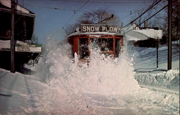 |
| Source: CardCow.com |
That's an amazing photo, and apparently it was taken three days after the snow stopped falling. And it took six hours to plow the line. (I think the only thing that's changed in this photo is that the overhead wire has been replaced with a catenary.) Even if the trains are running and the tracks are clear, it takes some time to clear off platforms so that people can get on to the trains. When it snows faster than crews can clear, which was certainly the case in this storm, a shut-down makes sense.
.JPG) |
| Tracks are clear at Longwood Station on Saturday morning, but the platforms are still buried. |
.JPG) |
| Skiers stride Beacon Street on Saturday as a snow clearance train rolls by. Service would not resume for another 24 hours. |
But what about the underground? The core segments of the MBTA run in tunnels, which are, by design, impervious to snow. Most stations have covered entrances, and those which do not could be top priority for shovel teams (Central Square, for instance), or have uncovered entrances temporarily closed (the Church Street entrance to Harvard, for example, or the auxiliary entrance in Kendall closer to the river). Intermediate, uncovered stations (Charles is the only one which comes to mind) could be temporarily closed, and the system could be run on a limited basis. For example:
 |
| Base map from Vanshnookenraggen, crudely cropped in, yes, MS Paint |
Would this serve everyone? Certainly not. But it does provide service to several important areas, including downtown, Back Bay, Kendall and the airport. It also provides service to near major hospitals which are, of course, open through the storm. (The platforms at Charles could be shoveled to provide service to MGH.) Keeping this much of the system operational—with all-night service in the case of a road travel ban—would be a huge show of good faith by the MBTA and would quell most of the complaints that they aren't doing enough to keep service running. It would also serve many travelers who have no other option during the storm. It, too, would take some advanced planning, but would provide better service.
I hope that, for the next storm, some of these steps will be taken. For instance, if service was better matched to the start of heavy snow and run through rush hour, then curtailed to underground portions of the system for the storm and then phased back in during the afternoon on Saturday, there would have been many fewer complaints about the overall storm service on the MBTA. This is not to say that the T didn't do a good job—having full service on Monday took quite a concerted effort. (In addition, overall kudos to MassDOT: the highway shutdown meant that, unlike in New York, cars were not stranded in snow drifts on main highways.) It would be nice, however, to have a better plan of action for future storms.
Friday, February 8, 2013
Boston is way over-plowed
With the blizzard hitting the Northeast, the media are in full useless-detail reporting mode. One of those useless facts is that the City of Boston has 600 plows at its disposal. That seems like a lot. So I looked up the number for Minneapolis, which I recently argued was at the low end of the snow clearance scale. While Boston has about a 50% higher population, both cities are about 50 square miles (Minneapolis is slightly bigger, in fact—and has alleys to clear to boot). They boast on their website of the wide array of snow-clearing equipment at its disposal—which amounts to 119 plows. That's less than a fifth of the number of plows in Boston. No wonder it seems they plow more here.


The Atlantic Cities looked at the number of plows a few weeks ago. New York, which equips is garbage truck fleet with plows during large storms, boasts 7.37 plows per square mile, more than double any other city. That's quaint. Boston didn't report their data. That's probably because Boston is off the charts: it nearly doubles New York with an astounding 12.4! Here's the Atlantic's chart:
I've taken this and enhanced it in two ways. One, I've added Boston, because it is pretty much off the charts. Second, I've calculated the snow plows per 100 inches per square mile.

Boston stands out for the plows per square mile, but if you further normalize the data by the total snow received, it has some cities which are more equal. New York gets less than two thirds the snow, so it has almost as many plows. Philadelphia and DC get far less snow—less than half—and they are closer. It seems that cities in the northeast, where the ocean creates infrequent, but very heavy, snows (like the storm right now) invest a lot more in having a lot of plows at their disposal. Kansas City does too, although as a far less dense city it has many more lane miles to plow, apparently.
Or maybe in Boston, it's just harder to plow all those streets that loop back on themselves (link not totally SFW).
Or maybe in Boston, it's just harder to plow all those streets that loop back on themselves (link not totally SFW).
Wednesday, February 6, 2013
Sort of off-topic
But I've blogged about maps of gun ownership in Minnesota over at Unconventional Data. Where do people own guns in Minnesota? Not necessarily where they vote Republican. Click over for more.
Subscribe to:
Posts (Atom)